 |
| Downtown Calgary 1924 |
After going through the election process and hearing about the multitude of issues in our city I thought it timely to post about our city back in 1924 since I've had the link to a City Of Calgary archived map from that era 93 years ago, complete with some interesting photos that show our tremendous growth. There were also some facts about the era, including some pertaining to an election.
- The Mayor at the time was George Webster and there was a total of 12 Aldermen on City council. Seems like a lot, considering the city has only 14 in 2017
- Voters needed to be 21 years of age or older and had to select aldermen based on 1st choice, 2nd choice, 3rd choice etc.
- It cost $67 to produce the 22,000 ballots used in the 1924 election
- 100 Civic employees did the official count
- For perspective, consider that a golf membership at the Shaganappi Golf Course was $10 for men and $8 for women, Model bread won the tender to supply the General Hospital with bread at ¢7 per loaf and the first ever Dominion Day celebration fireworks cost $197
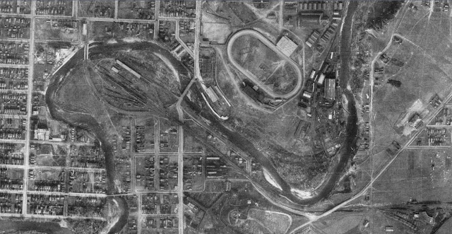
Here are a few area maps showing how much has changed in 93 years. The photos are from a compilation of 138 taken from a height of 2272 m (7500 ft.) in a Vickers Viking Biplane
This area is Macleod Trail at the Elbow River, with Stampede Park on the right. Note that the racetrack is situated quite a bit further east than the present day track. There is a railway running along what is now 25 Ave. S.E., and what is now Lindsey Park and the Repsol Centre was once a rail yard.
This photo shows 16 Ave., NW. at the top, intersected by 14 St on the left and 10 St on the right. I couldn't find out just what the building and other structures are in the centre of the area that now hosts the North Hill Mall, which coincidentally was Calgary's first, built in 1958.
Macleod Tr at 42 Ave.,S.E., which seems to be the edge of town in 1924. That would be Stanley Park in the middle of the frame, with Elbow Dr on the left.
The road running horizontally through the middle of this photo is Glenmore Tr, so this photo shows the area that would eventually be the Glenmore Reservoir. Of course, Crowchild Tr will eventually run north -south on the left hand side of the frame and tie in to Glenmore.
That's Bowness Rd on the far right side of the frame, crossing over the Bow River. The Trans-Canada/16 Ave. will eventually cut through here, running parallel to the railway tracks that still exist to this day. Bowness would eventually be incorporated into a village in 1948, a town in 1951 and a part of Calgary in 1963.
This photo shows what was the village of Midnapore, way out of the Calgary city limits. Of course, a lot has changed since 1924 and the community of Midnapore is many kilometres inside the south edge of the city now.
On the far right is the town of Forest Lawn, way east of the city. Pearce Estate Park is still tucked away in that bend in the Bow.


No comments:
Post a Comment